

Home :: Geography Of India
Geography of India
India is set apart from the rest of Asia by the Himalayas, the uppermost, youngest and still developing mountain chain on the planet. The subcontinent as it is correctly called, touches three large water bodies and is immediately familiar on any world map. This broad, roughly triangular peninsula defines the Bay of Bengal to the east, the Arabian Sea to the west, and the Indian Ocean to the south. India holds nearly every kind of landscape imaginable. An abundance of mountain ranges and national parks give ample opportunity for eco-tourism and trekking, and its pure size promises something for everyone. From north to south India expands a good 2000 miles (3200 km), where the island nation of Sri Lanka seems to be squeezed out of India like an immense tear, the synapse forming the Gulf of Mannar.
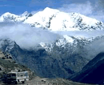
Himalayas, the world's highest mountain chain and Nepal as its Neighboring country rule India's northern border. Following the sweeping mountains to the northeast, its borders thin to a small channel that passes between Nepal, Tibet, Bangladesh, and Bhutan, then spreads out again to meet Burma in the "eastern triangle." Apart from the Arabian Sea, its western border is defined completely by Pakistan.
North India is the country’s biggest region begins with Jammu and Kashmir, with terrain unreliable from the mountains in the far north to the lake country and forests near Srinagar and Jammu. Moving south along the River Indus, the North becomes most hospitable and flatter; broaden into the fertile plains of Punjab to the west and the Himalayan foothills of Uttar Pradesh and the Ganges river valley to the East. Cramped between these two states is the capital city, Delhi.
The states of Gujarat, Maharashtra, Goa, and part of the enormous, central state of Madhya Pradesh constitute West India. Extending from the Gujarat peninsula down to Goa, the west coast is wrinkled with some of India's best beaches. The land along the coast is classically lush with rainforests. The Western Ghats divide the verdant coast from the Vindya Mountains and the dry Deccan plateau further inland.
India is the home of the holy River Ganges and the majority of Himalayan foothills, East India begin with the states of Madhya Pradesh, Bihar, Orissa, which include the westernmost part of the region. East India also contains an area known as the eastern triangle, which is completely distinct. This is the last gulp of land that extends further than Bangladesh, culminating in the Naga Hills along the Burmese border.
India reaches its peninsular tip with South India that begins with the Deccan in the north and ends with Cape Comorin. The states in South India are Karnataka, Andhra Pradesh, Tamil Nadu, and Kerala, a preferred leisure destination. The southeast coast, mirroring the west, also rests cozily beneath a mountain range---the Eastern Ghats.
