Home ::Indian National Parks ::Silent Valley National Park
Silent Valley National Park
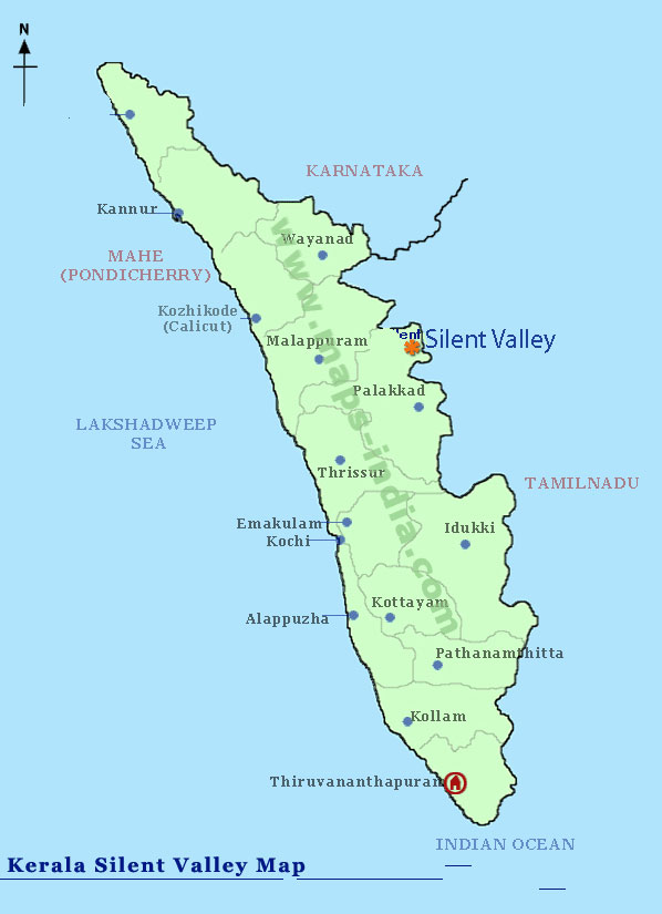
Silent Valley National Park (Core zone: 236.74 square kilometres (91 sq mi)) is located in the Nilgiri Hills, Palakkad District in Kerala, South India. The area in this national park was historically explored in 1847 by the botanist Robert Wight, and is associated with Hindu legend. The park is one of the last undisturbed tracts of South Western Ghats mountain rain forests and tropical moist evergreen forest in India. Contiguous with the proposed Karimpuzha National Park (225 km²) to the north and Mukurthi National Park (78.46 km²) to the north-east, it is the core of the Nilgiri International Biosphere Reserve (1,455.4 km²), and is part of The Western Ghats World Heritage Site, Nilgiri Sub-Cluster (6,000+ km²) THUNDER consideration by UNESCO. Plans for a hydroelectric project that threatened the parks high diversity of wildlife stimulated an environmentalist Social Movement in the 1970s called Save Silent Valley which resulted in cancellation of the project and creation of the park in 1980. The visitors' centre for the park is at Sairandhri.

The area is locally known as "Sairandhrivanam" literally, in Malayalam: Sairandhri's Forest. In local Hindu legend, Sairandhri is Draupadi, the polyandrous wife of the five Pandavas, who disguised herself as Sairandhri, queen Sudeshna's assistant, while they were in exile. The Pandavas, deprived of their kingdom, set out on a 14-year exile. They wandered south, into what is now Kerala, until one day they came upon a magical valley where rolling grasslands met wooded ravines, a deep green river bubbled its course through impenetrable forest, where at dawn and twilight the tiger and elephant would drink together at the water's edge, where all was harmonious and man unknown. Beside that river, in a cave on a hill slope, the Pandavas halted.
Buffer zone
Territorial forests located around the national park have been subject to a working-plan to accomplish revenue oriented objectives such as extraction of bamboo and reed which affect the long-term conservation of the park. In addition Illegal activities such as ganja cultivation, setting forest fires, trapping and poaching wild animals, frequently occur in the territorial forests located in the immediate vicinity of the national park. This has resulted in degradation of habitat and reduced forest cover, which has adverse effects on the long term survival of the core area of the national park.

On November 21, 2009, Union Minister of Forest and Environment Jairam Ramesh and Kerala Forest Minister Binoy Viswam declared, while inaugurating the silver jubilee celebration of Silent Valley National Park in Palakkad, that the buffer zone of the Park would be made an integral part of it in order to ensure better protection of the area. This means that the total park area is now increased to 236.74 square kilometres (91 sq mi). On June 6, 2007 the Kerala cabinet approved the buffer zone proposal. The new 147.22 km² zone will include 80.75 km² taken from Attapady Forest Range, 27.09 km² from Mannarkkad Forest Range and 39.38 km² from Kalikavu Forest range and consolidated to form a new range, Bhavani Forest Range, of 94 km² and 54 km² would be brought under the existing Silent Valley Range of the National Park. The Cabinet also sanctioned 35 staff to protect the area and two new forest stations in Bhavani range at Anavai and Thudukki. Forest Minister Benoy Viswom said "the zone would have reserve forest status and tribals in the area would not be affected. The decision reaffirmed the commitment of the LDF Government to protection of environment. The zone is a necessity, not just of the State but also of the nation."
Geography
Silent Valley is rectangular, 7 km (east-west) X 12 km (north-south). Located between 11°03' to 11°13' N latitude and 76°21' to 76°35' E longitude it is separated from the eastern and northern high altitude plateaus of the (Nilgiris Mountains) by high continuous ridges including Sispara Peak (2,206 m) at the north end of the park. The park gradually slopes southward down to the Palakkad plains and to the west it is bounded by irregular ridges. The altitude of the park ranges from 658 m to 2328 m at Anginda Peak, but most of the park lies within the altitude range of 880 m to 1200 m. Soils are blackish and slightly acidic in evergreen forests where there is good accumulation of organic matter. The underlying rock in the area is granite with schists and gneiss, which give rise to the loamy laterite soils on slopes.
Rivers
The Kuntipuzha River drains the entire 15 km length of the park from north to south into the Bharathapuzha River. Kuntipuzha River divides the park into a narrow eastern sector of width 2 kilometers and a wide western sector of 5 kilometers. The river is characterized by its crystal clear and perennial nature. The main tributaries of the river, kunthancholapuzha, Karingathodu, Madrimaranthodu, Valiaparathodu and Kummaathanthodu originate on the upper slopes of the eastern side of the valley. The river is uniformly shallow, with no flood plains or meanders. Its bed falls from 1,861 m to 900 m over a distance of 12 km, the last 8 km being particularly level with a fall of only 60 m. Kuntipuzha is one of the less torrential rivers of the Western Ghats, with a pesticide-free catchment area.
Climate
Silent Valley gets copious amounts of rainfall during the monsoons, but the actual amount varies within the region due the varied topography. In general the rainfall is higher at higher altitude and decreases from the west to east due to the rain shadow effect. Eighty per cent of the rainfall occurs during the south-west monsoon between June and September. It also receives significant amount of rainfall during the north-east monsoon between October and November.
The park being completely enclosed within a ring of hills, has its own micro-climate and probably receives some convectional rainfall, in addition to rain from two monsoons. In the remaining months, condensation on vegetation of mist shrouding the valley is estimated to yield 15 per cent of the total water generated in the rainforest.
In 2006, the Walakkad area of the park received the highest ever annual rainfall of 9,569.6 mm. In 2000, the figure was 7,788 mm; in 2001, 8,351.9 mm; in 2004, 8465.3 mm; and in 2005, 9,347.8 mm. The annual rainfall received in the valley (at Sairandhri?) was 7,788.8 mm in 2000; 8,361.9 mm in 2001. In 2002, 4,262.5 mm; in 2003, 3,499.65 mm; in 2004, 6,521.27 mm, in 2005, 6,919.38 mm; in 2006, 6,845.05 mm; in 2007, 6,009.35 mm; and in 2008 it was 4386.5 mm. The figure till October 2009 was 5,477.4 mm. Average annual rainfall in the park between 2000 and 2008 was thus 6,066 mm.
The mean annual temperature is 20.2 °C. The hottest months are April and May when the mean temperature is 23 °C and the coolest months are January and February when the mean temperature is 18 °C. Because of the high rainfall, the relative humidity is consistently high (above 95%) between June and December.


