Friday, October 30, 2009
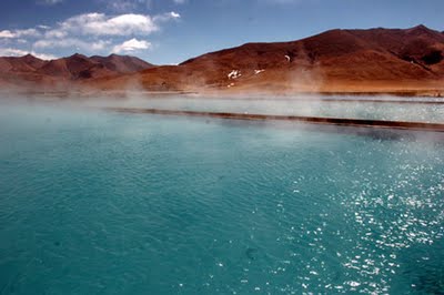 Tibet boasts the most hot springs in China. Yambajan, world-famous for its spectacular phenomenon of hot springs boiling on the cold plateau, features all kinds of hot springs including highest-temperature hot springs, boiling springs and geysers as well as common hot springs, the area of which totals more than 7,000 square meters. The early morning in Yambajan is the most beautiful. In the cold morning, the hydrothermal fields are always suffused with white haze and the lake surface is always covered with great steam agglomerations, which is really fascinating and makes Yambajan a wonderland. If you are lucky enough, you may have a chance to witness the fantastic and splendid scene: the boiling water is erupting to the sky from the mouth of hot spring. Yambajan features eight spectacular scenic spots. The first: Bread-Steaming Hot Spring. Bread can be steamed over the hot springs near Tsangpuqu River in the southeast Yambajan. The second: Fish-Cooking River. The melted ice and snow flowing down from mountains converges to be the water of Tsangpuqu River, which, when flowing across Yambajan, is boiled by the heat erupting from the riverbed. As a result, the fish swimming here are cooked, floating on the surface of the water and becoming the food of passing-by birds and animals. The third: Noodle-Cooking Hot Spring. Around a limpid stream in the southwest Yambajan bestrew a lot of small hot springs, from the mouth of which, the boiling water with the temperature of 90 0c bubbles out and can cook noodles and eggs. The four: Alkali-Liquor-puffing Fountain. In the southwest Yambajan, a big fountain with a diameter of 1.5 meters can puff alkali liquor. The fifth: Vinegar Boiling Spring. With a diameter of 1 meter and a depth of 4 meters, the milk-white acid boiling spring is as delicious as the Shanxi Vinegar (a famous vinegar in China). The sixth: Hot Water Lake. The lake, located in the northeast basin, is as big as more than 20 basketball courts. The highest temperature of the lake middle reaches 57.7 0c. There was a folktale about the lake. It was said to be a big natural bathing pool that Jade Emperor constructed for the female court attendants in the heaven, who would bath in the lake in the evening. The seventh: Warming Ditches. At the foot of a mountain in the north Yambajan, there are four ditches covered with soft grit. Getting off the bus and sitting on the soft grit, you will find yourself sitting by the fireplace, warm and comfortable all over. The eighth: Sulphur Ditch. Location Covering an area of about 150,000 square meters, Yambajan, 87 kilometers away from Lhasa, is situated in the basin at the foot of Nyainqentanglha Mountains to the northwest of Lhasa. Labels: Beauty Tourism, Tourism attractions, World Tourism
Thursday, October 29, 2009
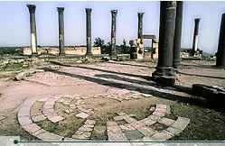 The modern town of Umm Qais is the site of the ancient Greco-Roman town of Gadara, one of the cities of the Decapolis and, according to the Bible, the place where Jesus cast out the devil from two men into a herd of pigs (Matthew 8: 28-34). Rising 518 meters above sea level with views of Lake Tiberias and the Golan Heights, there is no better vantage point in northern Jordan than Umm Qais.
Gadara was renowned for its cosmopolitan atmosphere, attracting an array of writers, artists, philosophers and poets. It also served as a resort for Romans vacationing in the nearby al-Hemma hot springs. Like Pella, its sister Decapolis city, Gadara was blessed with fertile soil, abundant water, and a location astride a number of key trading routes connecting Asia and Europe.
The city was probably founded by the Greeks during the fourth century BCE. Gadara was overrun by the Seleucid ruler Antiochus III in 218 BCE. When the Romans under Pompey conquered the East and formed the Decapolis, the fortunes of Gadara, taken in 63 BCE, improved rapidly and building was undertaken on a large scale. During the early part of Roman rule, the Nabateans (with their capital at Petra) controlled the trade routes as far north as Damascus. Aiming to put an end to this competition, Mark Antony sent King Herod the Great to weaken the Nabateans, who finally gave up their northern interests in 31 BCE. In appreciation for his efforts, Rome rewarded Herod with Gadara. The city remained under Herod’s rule until his death, and then reverted to semi-autonomy as part of the Roman province of Syria. Labels: Beauty Tourism, Countries Tourism, Tourist spots, World Tourism, World travel tourism
Tuesday, October 27, 2009
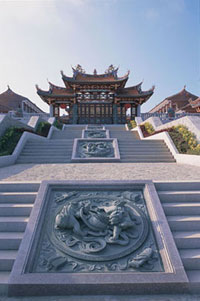 Close to the world's tallest statue of the goddess A-Ma (also known as Tian Hou), which stands on a 170-metre high peak on a mountaintop on Macau's Coloane Island, a 7,000-square meter cultural complex celebrates the beloved deity's legend. The development of the A-Ma Cultural Village was started during the Chung Yeung festival in 2001 shortly after the A-Ma Cultural and Tourism Festival of Macau. Today, construction of the Qing Dynasty-style complex is nearly finished. Surely the village, which comprises a bell tower, drum tower, carved marble altar in the Tian-Hou Palace, a dressing hall, museum and shops will attract many A-Ma devotees and interested tourists, especially those from the Mainland, Taiwan, Hong Kong and Fujian Province, where the goddess A-Ma is believed to have been born more than 1,000 years ago. Visitors approach the village by six rows of stairs carved with auspicious Chinese patterns like of the roaring tiger, the double lion, the five cranes and double phoenix that lead to the Tian Hou Palace. Plans for the future include a vegetarian restaurant and more Macanese and Taiwanese snack stalls, folk handicrafts and souvenir shops and other tourist facilities. Labels: Countries Tourism, Tourism attractions, World Tourism, World travel guide
Monday, October 26, 2009
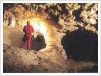 A tunnel cave connecting a sink in the downstream end of valley in pinnacle karst to a resurgence at the rim of (the locally) shallow limestone outcrop below Matrongkol. An inspiring entrance (15m wide, 3.5m high) leads to a boulder collapse obstructed by driftwood but a squeeze to the top of a 2m climb down gains a dirty, shallow pool from where a north-south running passage (on average 7 m wide, 2.5 m high) continues below a daylight window (15m above) to enter a Y-junction. Here North South passage turns to the right, continuing all the way (185m, inclined by-7º) to the resurgence as a North-North East-South-South West passage. Some 50m from the Y-junction, the main drag splits into two parallel 20m-passages (the right/north-western one requires swimming but the left is dry). They unite at a cross-rift chamber, split again, and re-unite once more to continue from then onward as a level passage to a daylight-lit collapse area at the rim of the limestone outcrop. Labels: Countries Tourism, Tourist spots, World Tourism, World travel guide, World Vacation
Sunday, October 25, 2009
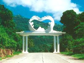 Known originally as Shuanglianku, Mount Zion was once an uninhabited, remote and desolate mountain located in Siaolin Village, in Jiasian Township, in Kaohsiung County. In 1963, God led Elijah Hong, Prophet of All Nations, to this mountain. In 1979, Elijah Hong was directed by God to settle down on Zion. From Zion, he brought forth the teachings of God. He also proclaimed, “God has forsaken Jerusalem in the Middle East. He has chosen Mount Zion in the Far East. Mount Zion in Siaolin as the mountain of the LORD’s house, as mentioned in the prophecy of Isaiah. All nations shall flow to this mountain on pilgrimage. They will come to worship the Great King of Zion!” Since then, saints from various parts of the world have begun coming to this mountain on pilgrimage. God’s chosen Mount Zion is located among the mountains that stretch across the counties of Kaohsiung, Tainan and Jiayi. It has a natural demarcation, and its terrain resembles a king’s throne. The trip to Mount Zion starts from Siaolin Village in Jiasian Township, Kaohsiung County. The road that leads to Mount Zion is Provincial Highway Tai 21, which runs alongside the Nanzihsian River. It takes about 10 minutes to drive to Bridge 12. By then, a towering retaining wall, an embankment, will be in sight. This majestic and impressive structure, 60 meters in height and more than 100 meters in length, is called Zion’s Stronghold. Now, here you are in Mount Zion. Labels: Beauty Tourism, Countries Tourism, Mount Zion, World Tourist Spots, World travel tourism
Friday, October 23, 2009
Morni is a tourist place in Morni Hills in Panchkula district of Haryana in India. Morni Hills are the offshoots of Shivalik range of the Himalayas, which run in two parallel ranges. The village of Morni (Bhoj Jabial) lies on the mountainside, at 1220 meters above mean sea level. Traditions assign the name of Morni to a Queen who is believed to have ruled this area. Among the spurs of hills, lie two lakes, the larger is about 550 meters long and 460 meters broad and the other about 365 meters either way. A hill divides the two lakes but there is some Hidden channel, as the level of two lakes remains the same. The people look upon the lakes as sacred. There is an old fort, which is now in ruins. The hills are covered by pine trees. The climate is salubrious and the area is suitable for trekking. The Haryana Government has developed this hill resort and provides facilities to tourists, a motorable road was constructed to connect the Morni hills with Haryana State Highway near Panchkula. A Forest Department rest house "Lal Munia" and a PWD rest house were also constructed to accommodate tourists and trackers. There are also small playgrounds for children. There is a roller skating rink and a swimming pool. It is an ideal place for tourists who want to avoid crowds and for those who love nature.There are a number of resorts that add to accommodation options and variability in and around Morni.It is a place that is frequented by nature starved people(whose tribe is ever growing in cities) on the weekends or holidays and it might be difficult to grab a decent meal at times in the high season.A decently stocked liquor vend and an attached snack shop that serves turmeric laden omelettes and toasted bread ,does for the meals to famished tourists. The best season to visit is September to March, because it might get hot or humid during the rest of the months and venturing might be overly-humid. It has 2 small man-made lakes called Tikkar Taal, bada tikkar and chota tikkar. Tikkar Taal offers good attraction for tourist and campers to frequent Morni. Campers accommodation in dormantories is made available by Haryana Tourism at Tikkar Taal. The road that descends from the zenith of the hillstation brings you to a seasonal waterfall that drops into a muddy lake but is aloof from crowds , so gives relaxation space and time .Further up the road takes you into Himachal pradesh.On the high point where the road forks for the steep descent for the twin lakes,at clear nights,especially after showers one can see the lights of chandigarh.The geometrically placed streetlights,neon or sodium vapour, & occasionally bright signboards, howsoever blurred tend to mesmerize you. There are three roads that connect Morni to chandigarh or other nearby towns(courtesy Haryana government), so one wont get stuck up in case of a blockade on any road, likely landslides in the rains.The town has grown so has time required to absorb the milleu and soak the nature and experience that it provides. Labels: India Tourism, Tourist spots, World Tourist Spots
Thursday, October 22, 2009
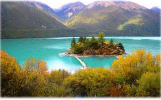
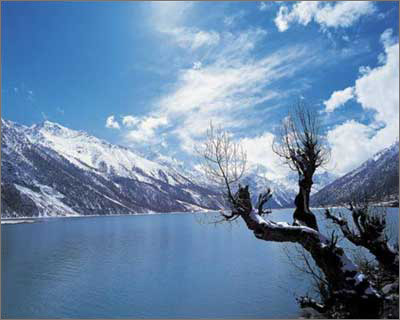 The Ranwu Lake is a perfect blending of the Swiss Alps snow peaks and glaciers and the streams in Jiuzaigou (a pretty town in central China). Just as depicted in the diary of Mr. Zhang Qingsong (a known professor from the School of Geography, Chinese Academy of Science who has set foot on all the three poles of the planet): “in my first journey to Tibet in 1975, I took a bus down the Sichuan-Tibet Highroad from Chendu to Lhasa. After passing the Henduan Moutain Range, the valleys of the Rivers of Jinsha, Lanchang and Lu, I stayed in the Ranwu Garrison overnight, the poetic scenery of the Ranwu Lake drove away all my fatigues. How amazing are those upright high peaks, white glacier, blue lake water, green grassland, floating white clouds, lush forest …” The Ranwu Lake, the largest in southeast of Tibet, is in the Village of Ran about 90 km from the Baiba Town neighboring the Nyingchi Prefecture. The lake, 3,800 meters above the sea level, has a water area of 22 square kilometers. On the bus ride from the Basu County, Chadu down the Sichuan-Tibet Highway (now the National Highway No. 318) one can see a corner of the lake. This is the most dangerous highroad in China. The Ranwu Lake is surrounded by many scenic highlights, e.g. the Gangrigabu Snow Mountain in the southwest, the Azhagongla Glacier in the south and the Bosula Peak in the northeast. The melted snow and ice supply the lake with sufficient water and are also the source of many rivers such as Yaluzhangbu. The green grassland around the lake, the sky-blue lake water and the white snow mountains constitute a very pretty watercolor. The Amucuo Lake shrinks westwards and finally became a river valley. Its water takes on different colors in different seasons of a year and the water surface is dotted with isles or reefs. Many of the peaks surrounding the lake are over 5, 000 meters high and thus permanently locked with glaciers. The foot of these peaks, however, is green with pines and cypresses. The lake is especially womanish and tranquil in the arms of the peaks, whose beauty goes beyond words. The browsing herds of cattle and sheep, the barley paddy, bean and cabbage field form an oil painting that can be seen no elsewhere. Labels: Beauty Tourism, Ranwu lake, World Tourism, World Tourist Spots, World travel tourism
Wednesday, October 21, 2009
 The Sultan Salahuddin Abdul Aziz Shah Mosque in Shah Alam is one of the most stunning structures in the country. Commonly referred to as the 'Blue Mosque', it boasts the tallest minarets in the world. As visitors approach the mosque, the awe-inspiring blue dome welcomes them. Decorative Islamic calligraphy dominates the edges surrounding the dome and main prayer hall, while the interior architecture exhibits ethnic Malay design elements. Sunlight filtering through the blue stained glass of the mosque renders a bluish ambience to its interior, evoking a sense of peace and serenity. The Blue Mosque overlooks the Garden of Islamic Arts, a beautifully landscaped park inspired by the Quranic Garden of Paradise. Covering 14 hectares, this spiritual sanctuary houses nine galleries that exhibit a rich array of Islamic arts such as calligraphy, sculptures, paintings and architecture. Occasionally, traditional Islamic performances are held here. Labels: Beauty Tourism, Blue Mosque, Countries Tourism, World travel tourism, World Vacation
Tuesday, October 20, 2009
Monday, October 19, 2009
 It boasts of the world's longest navigable underground river. This site is currently ranked number 8 on the list of New Seven Wonders of the World. The Puerto Princesa Subterranean River National Park is located about 50 km north of the city of Puerto Princesa, Palawan, Philippines. It features a limestone mountain landscape with an 8.2 km. navigable underground river. A distinguishing feature of the river is that it winds through a cave before flowing directly into the South China Sea. It includes major formations of stalactites and stalagmites, and several large chambers. The underground river is reputed to be the world's longest navigable. At the mouth of the cave, a clear lagoon is framed by ancient trees growing right to the water's edge. Monkeys, large monitor lizards, and squirrels find their niche on the beach near the cave. Labels: Puerto Princesa Subterranean River, Tourism attractions, Travel, World Tourism, World Tourist Spots
Thursday, October 15, 2009
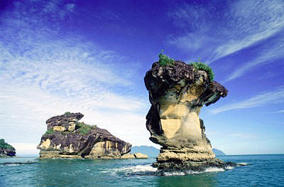 Sarawak's oldest national park was established in 1957, covers a modest 27 sq. km., and is about 37km from Kuching. It's known for its extraordinary natural scenery, habitats, plants and wild life. Its most significant features are secluded coves and rugged rocky headlands with magnificent steep cliffs that overlook the South China Sea. The sea spray, wave action and the wind have also carved out magnificent sea arches and sea stacks at the base of the cliffs, some rearing above the waves like a mighty serpent's head. The attractive sandstone formations appear pink with iron patterns on the cliff. Further inland, waterfalls tumble down into freshwater pools in a tranquil and idyllic jungle setting. Bako contains an incredible variety of plant species and vegetation types, and this is one of the park’s great attractions. At Bako it is possible to see almost every type of vegetation found in Borneo. Bako is also home to approximately 275 rare proboscis monkeys, found only in Borneo. The best times for seeing wildlife at Bako are just after dawn and just before dusk, when the animals are at their most active. Bako is a fascinating place for bird watching, as over 150 species have been recorded here. Bako’s extensive trail system is made up of 16 colour-coded jungle trails which offer a range of walking and hiking options. The fit and adventurous can opt for full-day jungle hikes or overnight camping expeditions, whilst those who prefer to take it easy can opt for a relaxing forest walk. Labels: Bako National Park, World Tourism, World Tourist Spots, World travel guide
Wednesday, October 14, 2009
 As soon as the train exits Caoling Tunnel, tourists will glimpse their first view of Turtle Island, floating upon the ocean surface. As the train tracks curve about, the view of Turtle Island will vary, so keep your eyes glued! Turtle Island, also known as Turtle Mountain Islet, is located 10 kilometers east of the Touchen Town coastline. It is a volcanic island located within the ocean, named for its similarity to a floating turtle. The island is 3.3 kilometers wide from east to west and 1.7 kilometers long, coming to a total area of 2.85 kilometers squared, with a total coastline of approximately 10 kilometers. However, even with its small size, there are steep cliffs, active hot springs, hills and peaks, erosion caves, lakes, cold springs, rare cliff vegetation and a rich ocean ecology. With the erosion of ocean water and the rise and fall of the tide, Turtle Island is indeed a beautiful gem in the ocean. Turtle Island is open to tourists beginning from the 1st of March to November the 30th, from 9AM~4PM. During June, July and August, the hours are extended from 9AM~5PM. Labels: Guishan Island, Tourist spots, World Holiday tour, World Tourism, World travel guide
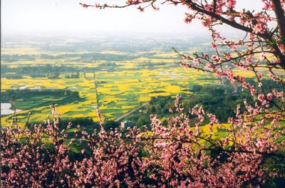 From march to may every year,along the way from Shou'an to Pujiang,flowers such as cauliflower,plum flower, peach, pear flower and citrus flower blossom with a great variety of shows.The scenery is filled with coulor of purple and red with flowers competing with each other.You may drive to the scenery and locate yourself at the mountain waist.Climbing the mountain and overlooking the view of Changqiu Mountain along the 2 banks of Pujiang river, you will enjoy the natural beauty to your heart content and feel relaxed and happy. Labels: Changqiu Mountain, Tourist spots, World Tourism, World travel guide
Tuesday, October 13, 2009
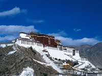 This architectural wonder is Lhasa' cardinal landmark. It can be seen from all directions for miles around. Potala was set up in the seventh century AD during the reign of King Songtsen Gampo. It's located on the Red Hill, covers an area of 41 hectares.
Potala consists of the White and Red palaces with more than 1000 rooms. The white places was for secular use.
It contained living quarters, offices, the seminary and the printing house. The red Palace's function was religious. It contained gold stupas, which were the tombs of eight Dalai Lamas, the monks' assembly hall, numerous chapels and shrines, and libraries for Buddhist Scriptures.
With its world-wide reputation, the Potala stands on the Red Hill overlooking the Tibetan city of Lhasa as a major national cultural monument under special protection by the government of the People's Republic of China.
The name of the large sacred Buddhist building complex is a derivation from Samskrit Potalaka which is the mythical mountain abode of Avalokitesvara, one of the Bodhisattvas (Buddhist saints). In this connection Lhasa is popularly referred to as Second Mount Potalaka.
At an elevation of more than 3,700m, the Potala occupies an area of more than 360,000m. Its 13-story main portion rises 117m. The whole complex, consisting of halls, stupa-tomb halls (where the relics of the supreme lamas are preserved), shrines, prayer rooms, monks' dormitories and courtyards, is recognized as the world's highest and largest castle palace.
Built against the terraced slope of the hill, the structures combine to from a huge sky-scraping mass, reminscent of the divine realm above the mortal world. The granite walls elaborately decorated with soft white thatch, the golden roofs decorated with big gilded bottles, the splendid curtains and banners, join to form a unique structural wonder bearing the striking colors red, white and yellow characteristic of Tibetan architectural art, making the Potala an eminent example of a constructive technology traditionally Tibetan and Chinese. Labels: Information tourism, Tourism attractions, World Tourism, World travel tourism
Sunday, October 11, 2009
 Philippines ecotourism is varied and unlimited. That is why there are groups of who wanted to promote Philippines as ecotourism destination. These groups are the Department of Environment and Natural Resources (DENR), Department of Tourism (DoT), ABS-CBN Foundation, Inc.’s Bantay Kalikasan, and Conservation International Philippines. These group has already agreed to work together for the promotion of the “Magandang Pilipinas”, a project that will boost up the country’s ecotourism and as a world-class ecotourism destination. The pilot ecotourism project sites that the parties has agreed to manage in a memorandum of agreement, has been identified as a high ecotourism potential with beautiful scenic attractions and are endowed with rich biodiversity. These sites are mostly protected area in the Philippines. Under the agreement, the parties agreed to manage existing and pre-identified ecotourism sites in the Philippines and promote specific ecotourism sites. The sites include the Verde Island Marine Passage Corridor in Batangas (center of the center of marine shorefish biodiversity’); Puerto Princesa Subterranean River National Park (underground river); Donsol, Sorsogon (whale shark watching); El Nido, Palawan (marine protected area and limestone karst); Tubbataha National Marine Park (coral reef); Banawe Rice Terraces, Ifugao; Mayon Volcano, Albay; Pamilacan, Bohol; Hundred Islands, Alaminos, Pangasinan; Sapang Bato, Angeles City, Pampanga; Lake Sebu, South Cotabato. The group believed that Philippines will excel in this area. Promoting the Philippines as a World Class Ecotourism Destination will boost up the influx of tourist, visitors and locals to the ecotourism sites that will surely generate income. Labels: Ecotourism, World Tourism
Wednesday, October 7, 2009
 "The Vatican Museums" one of your main tourist destinations. It is to be found in Viale Vaticano in Rome, within the Vatican City. Vatican Museums are one of the best museums in the world, since they show works from the vast collection built up by Roman Catholic Church during the centuries. The museums were originated in the 16th century by Pope Julius II. The Sistine Chapel and the Stabze della Segnatura bedecked by Raphael are on the guest route through the Vatican Museums. As of 2007, it was visited by 4,310,083 citizens for the year. Labels: World Tourism
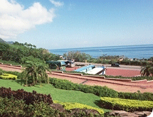 The Dali Tiangong Temple is visible after passing Shicheng, where it sits at the foot of green mountains. The Dali Visitor Service Center is located to the side of the temple, and is a location first timers must visit to understand Dali and collect valuable information. Construction on the Cingyun Temple, commonly known as Tiangong Temple, was first started during the reign of Qing Emperor Dao Guang, and was completed during the reign of Guang Xu. The Tiangong Temple worships the Jade Emperor, also known as Tiangong to commoners, and more specifically is a statue of the Jade Emperor originally from Fuzhou, China. He forms the center of belief for local residents, and the ninth day of the first month of the Lunar calendar is a day of local celebrations and ceremonies, when worshippers from everywhere arrive to participate. A small trail besides the temple leads to the Caoling Historic Trail. This historic trail can be said to be the first trail that connected east and west Taiwan directly. Along the way there are many different types of flora. When following the winding trail the gentle sound of streams can be heard with terraced fields and intersecting footpaths of fields in view. In the summer the whole mountain smells of Ginger Lily, while in autumn, tourists will see whole meadows of Silver Grass flowing in waves everywhere. Indeed, the Caoling Historic Path is the most popular hiking trail in the Northeast Coast. Labels: World Tourism
Tuesday, October 6, 2009
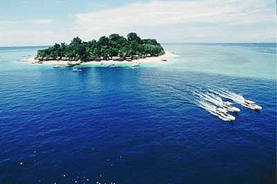 Sipadan island, one of the best diving spots in the world, is set to qualify for the final round of the New Seven Wonders of Nature. Sipadan is one of the 261 national and multinational nominees from 222 countries which participated in the search. Sipadan is the only oceanic island in Malaysia, rising 600m from the seabed, and is located in the Celebes Sea east of the major town of Tawau and off the coast of East Malaysia on the Island of Borneo. It is located at the heart of the Indo-Pacific basin, the centre of one of the richest marine habitats in the world and more than 3,000 species of fish and hundreds of coral species have been classified in this ecosystem. Labels: Sipadan Island, World Tourism
Monday, October 5, 2009
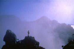 Mountainous landscapes of the WHA Mountainous landscapes of the WHAThe Tasmanian Wilderness World Heritage Area (WHA) is one of the largest conservation reserves in Australia, covering 1.38 million hectares, or about 20% of the island of Tasmania, the southern-most State of Australia. It conserves a diverse array of both natural and cultural features of outstanding global significance. The region provides pristine habitats for a range of plants and animals that are found nowhere else in the world, including many rare and endangered species. For a number of animals which have become extinct on mainland Australia in recent times, the area offers a last refuge. The WHA is the Australian stronghold of temperate rainforest and alpine vegetation. Its landforms are of immense beauty and reveal a rich and complex geology. Aboriginal occupation extending back beyond 36 000 years, combined with nearly two centuries of European settlement, have created a legacy of humanity's interaction with the wilderness. Labels: India Tourism
Thursday, October 1, 2009
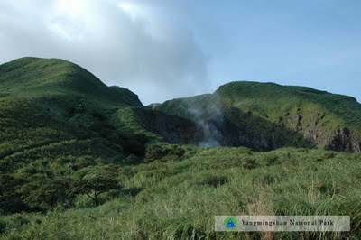 Hsiaoyukeng is the best-known recreation site in Yangmingshan National Park, and offers some of the most typical scenery. Located above the Tatung Bridge along the Yangmingshan-Chinshan Highway, Hsiaoyukeng is at an elevation of 800 meters and contains a host of volcanically-created fumaroles, sulfur crystals, hot springs, and landslides. Sulfur vents noisily spew forth gases, and hot springs discharge endless streams of boiling water. The bright yellow sulfur crystals that can be seen here are exceptionally lovely. Mt. Chihsing provides breathtaking views in all directions.
|


